


Washington Precinct, Nemaha County, Nebraska
About
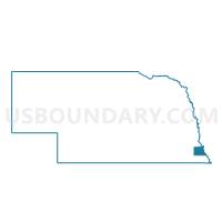
Outline

Summary
| Unique Area Identifier | 613651 |
| Name | Washington Precinct |
| County | Nemaha County |
| State | Nebraska |
| Area (square miles) | 107.99 |
| Land Area (square miles) | 107.98 |
| Water Area (square miles) | 0.01 |
| % of Land Area | 99.99 |
| % of Water Area | 0.01 |
| Latitude of the Internal Point | 40.34346720 |
| Longtitude of the Internal Point | -95.97336240 |
Maps

Graphs
Select a template below for downloading or customizing gragh for Washington Precinct, Nemaha County, Nebraska


Neighbors
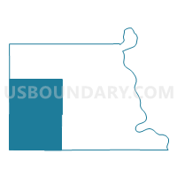
Neighoring Voting District (by Name) Neighboring Voting District on the Map
- 1st Douglas Precinct, Nemaha County, NE
- 3rd Douglas Precinct, Nemaha County, NE
- 4th Douglas Precinct, Nemaha County, NE
- Franklin/Humboldt Rural/Speiser Precinct, Richardson County, NE
- Lafayette Precinct, Nemaha County, NE
- Nemaha Precinct 2, Johnson County, NE
- Spring Creek Precinct, Johnson County, NE
- Table Rock Precinct, Pawnee County, NE
- Todd Creek Precinct, Johnson County, NE
- West Muddy/Porter Precinct, Richardson County, NE
Top 10 Neighboring County Subdivision (by Population) Neighboring County Subdivision on the Map
- Washington precinct, Nemaha County, NE (716)
- Spring Creek precinct, Johnson County, NE (542)
- Precinct 3, Table Rock, Pawnee County, NE (409)
- Douglas precinct, Nemaha County, NE (314)
- Todd Creek precinct, Johnson County, NE (308)
- Lafayette precinct, Nemaha County, NE (305)
- Glen Rock precinct, Nemaha County, NE (273)
- Benton precinct, Nemaha County, NE (211)
- Bedford precinct, Nemaha County, NE (190)
- Lincoln precinct, Johnson County, NE (147)
Top 10 Neighboring Place (by Population) Neighboring Place on the Map
Top 10 Neighboring Unified School District (by Population) Neighboring Unified School District on the Map
- Auburn Public Schools, NE (5,702)
- Johnson County Central Public Schools, NE (4,584)
- Humboldt Table Rock Steinauer Public Schools, NE (3,300)
- Johnson-Brock Public Schools, NE (1,347)
Top 10 Neighboring State Legislative District Upper Chamber (by Population) Neighboring State Legislative District Upper Chamber on the Map
Top 10 Neighboring 111th Congressional District (by Population) Neighboring 111th Congressional District on the Map
Top 10 Neighboring Census Tract (by Population) Neighboring Census Tract on the Map
- Census Tract 9682, Nemaha County, NE (3,653)
- Census Tract 9681, Nemaha County, NE (3,595)
- Census Tract 9676, Johnson County, NE (3,206)
- Census Tract 9678, Pawnee County, NE (2,773)
- Census Tract 9675, Johnson County, NE (2,011)
- Census Tract 9685, Richardson County, NE (2,008)
Top 10 Neighboring 5-Digit ZIP Code Tabulation Area (by Population) Neighboring 5-Digit ZIP Code Tabulation Area on the Map
- 68305, NE (4,389)
- 68450, NE (3,182)
- 68376, NE (1,445)
- 68378, NE (680)
- 68447, NE (464)
- 68320, NE (369)
- 68348, NE (256)